The weather of late has been glorious! We appreciate surfers have been disgruntled by the lack of swell (to say the least) of late. But you can’t knock the sunny blue skies we’ve been having. Well, there’s good news (if you believe weather forecasts).
The run of sunny conditions looks set to continue. And with this an increase in temperatures. Next week, potentially, looks proper warm in a lot of areas. A few risks of showers may present themselves but hopefully these will be short lived.
It’s also worth noting that water temperatures are getting warmer. Early mornings may still see the need fo thicker rubber if you’re headed for the brine. But later in the day should allow chance to shed some wetsuit thickness. Whatever wetsuits you’re needing don’t forget NCW can cater to all your needs.
Here’s what the Met Office said in their long range weather forecast –
‘Sunday 11 Jun – Tuesday 20 Jun‘
‘Plenty of dry weather with a good deal of sunshine continuing for most. An area of showers likely moving in from the southwest. These possibly heavy and thundery at times, perhaps most likely across the south and west. This area likely to make progress northeasterly across much of the UK through the weekend but low confidence around exact details of this progression, plus the degree of activity. Temperatures generally widely very warm, locally hot, and becoming humid especially in the south and southeast. Winds generally light or moderate for most areas. Later, most likely plenty of fine and settled weather with sunny and clear conditions for many parts. Likely to be warmer than normal for much of the UK. Risk of showers, possibly heavy and thundery, especially in southern parts.’
‘Wednesday 21 Jun – Wednesday 5 Jul’
‘More likely continuation of the fine and settled weather with a risk of showers through mid-July. High pressure re-orientate to lie near the southwest with low to the north. This brings a greater chance of rain to the west and northwest. Most likely temperatures trending back towards average or above. Very unlikely to be cooler than normal. · Low confidence in detail, as is often the case in summer.’
Our friends at UK weather forecasts also published this –
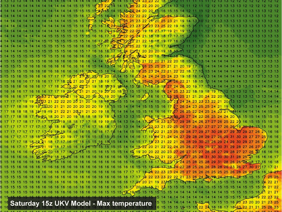
‘Anyone for 31ºc? The latest UKV model data really ramps up the temperatures for Saturday across central, eastern and south-eastern areas. We’ll also see some rather lively thunderstorms developing over the weekend!’
If you’re thinking of heading to the beach this weekend then it should be a great weekend for it. And the same goes for the following week. Embrace the weather as who knows how long it’ll last.
Be sure to check out NCW’s webshop for all your watersports and beach toy needs here.